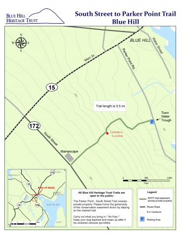
Click here to download a full-page map (PDF). Click Here to Download the PDF of the Heart of Blue Hill Trail System: Parker Point to South Street-Murphy-Kaiser
A connector trail in the village of Blue Hill
This conserved land covers 11 acres and provides an undeveloped corridor between two areas of town. The 0.5 mile trail can be used as a scenic shortcut between the South Street shopping area and Blue Hill’s village center. The trail cuts through a mixed wood forest occupying the gently sloping landscape and crosses several intermittent streams.
Location and Parking
The Parker Point Road trailhead is located at the old town fountain, 0.3 mile from Main Street. The South Street trailhead is 0.3 mile from the intersection with Route 15. Park on the road shoulder near the trailhead.
Please note: This trail crosses privately-owned land, protected by conservation easements. Public access is made possible by the generosity of the landowner. Please take extra care to stay on marked trails and leave the land as you found it.